Your Safer Source for Science
All-In-One Science Solution
Your Safer Source for Science
;
Address P.O. Box 219 Batavia, IL 60510
Phone 800-452-1261
Fax
Email [email protected]

Modeling and Mapping Topography—Student Activity Kit

By: The Flinn Staff

Item #: AP7315 

Price: $46.01

In Stock.

Modeling and Mapping Topography Classroom Activity Kit for Earth science is a three-part activity that will give you a better sense of direction in three dimensions.

See more product details

Product Details

Give students a better sense of direction in three dimensions with this exploration of topography-related concepts. In this three-part activity, students will investigate how elevation and landforms are represented on contour-relief maps. 

Kit activities include:
• Identifying common topographic map symbols
• Analyzing a topographic map
• Building a 3-D contour model

Complete for 30 students working in pairs.

Specifications

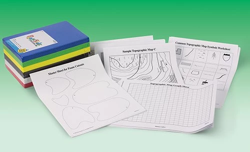
Materials Included in Kit: 
Common map symbols sheet, 15
Foam sheets, 8½" x 5½", pkg/50
Master sheet for foam cutouts, 15
Sample topographic map sheet a, 10
Sample topographic map sheet b, 10
Sample topographic map sheet c, 10
Topographic map, graph sheet, 30


Correlation to Next Generation Science Standards (NGSS)

Science & Engineering Practices

Developing and using models

Disciplinary Core Ideas

MS-ESS2.B: Plate Tectonics and Large-Scale System Interactions
HS-ESS2.B: Plate Tectonics and Large-Scale System Interactions

Crosscutting Concepts

Patterns
Scale, proportion, and quantity
Systems and system models