Your Safer Source for Science
All-In-One Science Solution
Your Safer Source for Science
;
Address P.O. Box 219 Batavia, IL 60510
Phone 800-452-1261
Fax
Email [email protected]
Mapping Earthquakes and Volcanoes Activity Kit for Earth science and geography is an active-learning mapping activity that investigates the geological question between earthquakes and volcanoes.

See more product details

Options:

(Select option to see volume pricing availability)

Product Details

Is there a geologic connection between Mother Nature’s most awesome displays of force—earthquakes and volcanoes—or is their occurrence simply coincidental? Let students discover the answer to this question with this active-learning mapping activity. Students first complete a puzzle of the Earth to learn the location of the Earth’s major tectonic plates. Then, using degrees of latitude and longitude, their own geographic knowledge and a chart of the ocean floor, students identify the locations of recent earthquakes and volcanoes. By comparing the marked locations on the chart with their completed puzzles, students are able to determine the geologic relationship.

Complete for 30 students working in pairs. Also includes information for accessing government websites to obtain the most recent listings of volcano and earthquake activity.

Correlation to Next Generation Science Standards (NGSS)

Science & Engineering Practices

Asking questions and defining problems
Developing and using models
Analyzing and interpreting data
Constructing explanations and designing solutions

Disciplinary Core Ideas

MS-ESS2.A: Earth’s Materials and Systems
MS-ESS2.B: Plate Tectonics and Large-Scale System Interactions
HS-ESS1.C: The History of Planet Earth
HS-ESS2.B: Plate Tectonics and Large-Scale System Interactions

Crosscutting Concepts

Patterns
Cause and effect
Scale, proportion, and quantity
Systems and system models
Stability and change

Performance Expectations

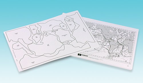
MS-ESS2-2. Construct an explanation based on evidence for how geoscience processes have changed Earth’s surface at varying time and spatial scales.
MS-ESS2-3. Analyze and interpret data on the distribution of fossils and rocks, continental shapes, and seafloor structures to provide evidence of the past plate motions.
HS-ESS1-5. Evaluate evidence of the past and current movements of continental and oceanic crust and the theory of plate tectonics to explain the ages of crustal rocks.
HS-ESS2-1. Develop a model to illustrate how Earth’s internal and surface processes operate at different spatial and temporal scales to form continental and ocean-floor features.